GeoPandas: paquete para agregar capacidades geoespaciales a pandas
GeoPandas es un proyecto de software libre que extiende los tipos de datos de pandas para incorporar objetos geométricos (puntos, líneas, polígonos, etc). GeoPandas se apoya en las bibliotecas Shapely para realizar las operaciones geométricas, Fiona para acceder a los datos (ej. en archivos) y Matplotlib para graficación.
El objetivo de GeoPandas es facilitar el trabajo con datos geoespaciales en el lenguaje Python, lo que se logra a través de la implementación de nuevas estructuras. Las dos estructuras principales de GeoPandas son:
GeoSeries: es un vector en el que cada elemento es un conjunto de una o varias geometrías correspondientes a una observación. Por ejemplo, el polígono (o multipolígono) que representa una provincia.
GeoDataFrame: es una estructura tabular (i.e. con filas y columnas) de datos geométricos y no geométricos (ej. textos, números). El conjunto de geometrías se implementa a través de GeoSeries.
Instalación
En una estación de trabajo
geopandas puede instalarse tanto mediante Conda como mediante pip.
# Instalación mediante Conda
conda install geopandas

# Instalación mediante pip
pip install geopandas
En Google Colab
# Instalación de bibliotecas de GDAL para Python
!apt install gdal-bin python-gdal python3-gdal

# Instalación de r-tree
!apt install python3-rtree

# Instalación de GeoPandas
!pip install git+git://github.com/geopandas/geopandas.git

# Instalación de Descartes
!pip install descartes
Carga
Para instalar contextily:
!conda install -c conda-forge contextily -y
import os
import requests
import zipfile

import pandas as pd

import geopandas as gpd
import contextily as cx
from geojson import dump
from owslib.wfs import WebFeatureService

import matplotlib
import matplotlib.pyplot as plt
# Versión de geopandas
gpd.__version__
'0.10.2'
Operaciones básicas
read_file() - carga de datos
# Lectura de datos de países de Natural Earth

paises = gpd.read_file(gpd.datasets.get_path('naturalearth_lowres'))

paises
| pop_est | continent | name | iso_a3 | gdp_md_est | geometry | |
|---|---|---|---|---|---|---|
| 0 | 920938 | Oceania | Fiji | FJI | 8374.0 | MULTIPOLYGON (((180.00000 -16.06713, 180.00000... |
| 1 | 53950935 | Africa | Tanzania | TZA | 150600.0 | POLYGON ((33.90371 -0.95000, 34.07262 -1.05982... |
| 2 | 603253 | Africa | W. Sahara | ESH | 906.5 | POLYGON ((-8.66559 27.65643, -8.66512 27.58948... |
| 3 | 35623680 | North America | Canada | CAN | 1674000.0 | MULTIPOLYGON (((-122.84000 49.00000, -122.9742... |
| 4 | 326625791 | North America | United States of America | USA | 18560000.0 | MULTIPOLYGON (((-122.84000 49.00000, -120.0000... |
| ... | ... | ... | ... | ... | ... | ... |
| 172 | 7111024 | Europe | Serbia | SRB | 101800.0 | POLYGON ((18.82982 45.90887, 18.82984 45.90888... |
| 173 | 642550 | Europe | Montenegro | MNE | 10610.0 | POLYGON ((20.07070 42.58863, 19.80161 42.50009... |
| 174 | 1895250 | Europe | Kosovo | -99 | 18490.0 | POLYGON ((20.59025 41.85541, 20.52295 42.21787... |
| 175 | 1218208 | North America | Trinidad and Tobago | TTO | 43570.0 | POLYGON ((-61.68000 10.76000, -61.10500 10.890... |
| 176 | 13026129 | Africa | S. Sudan | SSD | 20880.0 | POLYGON ((30.83385 3.50917, 29.95350 4.17370, ... |
177 rows × 6 columns
info() - información general sobre un conjunto de datos
paises.info()
<class 'geopandas.geodataframe.GeoDataFrame'>
RangeIndex: 177 entries, 0 to 176
Data columns (total 6 columns):
 #   Column      Non-Null Count  Dtype
---  ------      --------------  -----
 0   pop_est     177 non-null    int64
 1   continent   177 non-null    object
 2   name        177 non-null    object
 3   iso_a3      177 non-null    object
 4   gdp_md_est  177 non-null    float64
 5   geometry    177 non-null    geometry
dtypes: float64(1), geometry(1), int64(1), object(3)
memory usage: 8.4+ KB
head(), tail(), sample() - despliegue de filas de un conjunto de datos
# Muestra de 10 filas
paises.head(10)
| pop_est | continent | name | iso_a3 | gdp_md_est | geometry | |
|---|---|---|---|---|---|---|
| 0 | 920938 | Oceania | Fiji | FJI | 8374.0 | MULTIPOLYGON (((180.00000 -16.06713, 180.00000... |
| 1 | 53950935 | Africa | Tanzania | TZA | 150600.0 | POLYGON ((33.90371 -0.95000, 34.07262 -1.05982... |
| 2 | 603253 | Africa | W. Sahara | ESH | 906.5 | POLYGON ((-8.66559 27.65643, -8.66512 27.58948... |
| 3 | 35623680 | North America | Canada | CAN | 1674000.0 | MULTIPOLYGON (((-122.84000 49.00000, -122.9742... |
| 4 | 326625791 | North America | United States of America | USA | 18560000.0 | MULTIPOLYGON (((-122.84000 49.00000, -120.0000... |
| 5 | 18556698 | Asia | Kazakhstan | KAZ | 460700.0 | POLYGON ((87.35997 49.21498, 86.59878 48.54918... |
| 6 | 29748859 | Asia | Uzbekistan | UZB | 202300.0 | POLYGON ((55.96819 41.30864, 55.92892 44.99586... |
| 7 | 6909701 | Oceania | Papua New Guinea | PNG | 28020.0 | MULTIPOLYGON (((141.00021 -2.60015, 142.73525 ... |
| 8 | 260580739 | Asia | Indonesia | IDN | 3028000.0 | MULTIPOLYGON (((141.00021 -2.60015, 141.01706 ... |
| 9 | 44293293 | South America | Argentina | ARG | 879400.0 | MULTIPOLYGON (((-68.63401 -52.63637, -68.25000... |
Selección de columnas
paises[["name", "pop_est"]]
| name | pop_est | |
|---|---|---|
| 0 | Fiji | 920938 |
| 1 | Tanzania | 53950935 |
| 2 | W. Sahara | 603253 |
| 3 | Canada | 35623680 |
| 4 | United States of America | 326625791 |
| ... | ... | ... |
| 172 | Serbia | 7111024 |
| 173 | Montenegro | 642550 |
| 174 | Kosovo | 1895250 |
| 175 | Trinidad and Tobago | 1218208 |
| 176 | S. Sudan | 13026129 |
177 rows × 2 columns
Selección de filas
# Países con población estimada mayor o igual a mil millones
paises[paises["pop_est"] >= 1000000000]
| pop_est | continent | name | iso_a3 | gdp_md_est | geometry | |
|---|---|---|---|---|---|---|
| 98 | 1281935911 | Asia | India | IND | 8721000.0 | POLYGON ((97.32711 28.26158, 97.40256 27.88254... |
| 139 | 1379302771 | Asia | China | CHN | 21140000.0 | MULTIPOLYGON (((109.47521 18.19770, 108.65521 ... |
Selección de filas y columnas en la misma expresión
paises.loc[paises["pop_est"] >= 1000000000, ["name", "pop_est"]]
| name | pop_est | |
|---|---|---|
| 98 | India | 1281935911 |
| 139 | China | 1379302771 |
plot() - mapeo
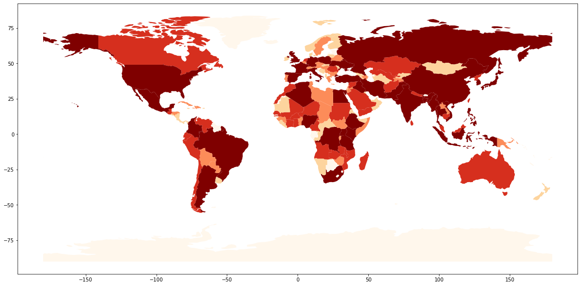
# Mapa de coropletas

paises.plot(column = "pop_est",
            cmap='OrRd',
            scheme='quantiles',
            figsize=(20, 20)
            )
<AxesSubplot:>
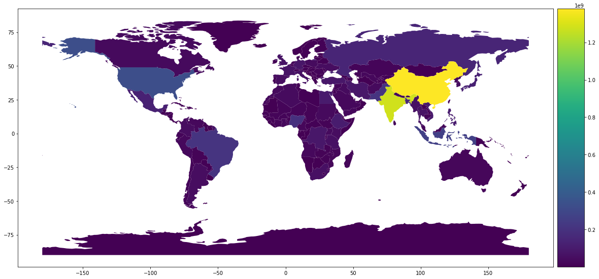
# Mapa de coropletas con leyenda

from mpl_toolkits.axes_grid1 import make_axes_locatable

fig, ax = plt.subplots(1, 1, figsize=(20, 20))

divider = make_axes_locatable(ax)
cax = divider.append_axes("right", size="5%", pad=0.1)

paises.plot(column='pop_est', ax=ax, legend=True, cax=cax)
<AxesSubplot:>
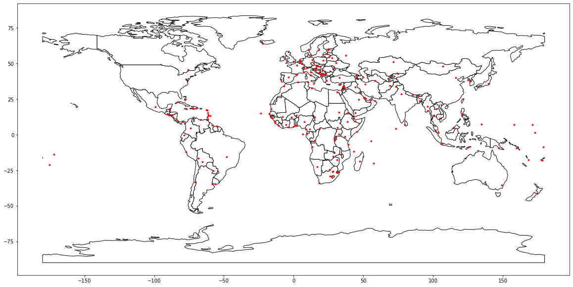
# Mapa con múltiples capas

ciudades = gpd.read_file(gpd.datasets.get_path('naturalearth_cities'))

base = paises.plot(color='white', edgecolor='black', figsize=(20, 20))
ciudades.plot(ax=base, marker='o', color='red', markersize=8)
<AxesSubplot:>
Ejemplos de uso
Análisis de distribución de especies de murciélagos en Costa Rica
1. Obtención de datos
Registros de presencia de murciélagos
# Descarga de archivo CSV comprimido en ZIP mediante solicitud tipo GET
response = requests.get('https://api.gbif.org/v1/occurrence/download/request/0105729-210914110416597.zip',
                        allow_redirects=True)
open('datos/murcielagos.zip', 'wb').write(response.content)

# Descompresión
with zipfile.ZipFile("datos/murcielagos.zip") as zipfile:
    zipfile.extractall("datos/")

# Cambio de nombre del archivo CSV
os.rename("datos/0105729-210914110416597.csv", "datos/murcielagos.csv")
# Carga de registros de presencia de murciélagos en un dataframe

murcielagos = pd.read_csv("datos/murcielagos.csv", sep="\t")
murcielagos
| gbifID | datasetKey | occurrenceID | kingdom | phylum | class | order | family | genus | species | ... | identifiedBy | dateIdentified | license | rightsHolder | recordedBy | typeStatus | establishmentMeans | lastInterpreted | mediaType | issue | |
|---|---|---|---|---|---|---|---|---|---|---|---|---|---|---|---|---|---|---|---|---|---|
| 0 | 3416142999 | 50c9509d-22c7-4a22-a47d-8c48425ef4a7 | https://www.inaturalist.org/observations/10118... | Animalia | Chordata | Mammalia | Chiroptera | Vespertilionidae | Rhogeessa | Rhogeessa io | ... | Yuzefovich Alexander | 2021-11-15T14:33:49 | CC_BY_NC_4_0 | jo22nfrog | jo22nfrog | NaN | NaN | 2021-12-08T05:34:32.772Z | StillImage | COORDINATE_ROUNDED |
| 1 | 3416092578 | 50c9509d-22c7-4a22-a47d-8c48425ef4a7 | https://www.inaturalist.org/observations/10131... | Animalia | Chordata | Mammalia | Chiroptera | Phyllostomidae | Uroderma | Uroderma bilobatum | ... | Merav Vonshak | 2021-11-17T06:37:32 | CC_BY_NC_4_0 | Merav Vonshak | Merav Vonshak | NaN | NaN | 2021-12-08T06:09:54.326Z | StillImage | COORDINATE_ROUNDED |
| 2 | 3415771696 | 50c9509d-22c7-4a22-a47d-8c48425ef4a7 | https://www.inaturalist.org/observations/88766024 | Animalia | Chordata | Mammalia | Chiroptera | Phyllostomidae | Artibeus | Artibeus jamaicensis | ... | Yuzefovich Alexander | 2021-07-27T06:38:03 | CC_BY_NC_4_0 | Alex Castelein | Alex Castelein | NaN | NaN | 2021-12-08T05:05:13.398Z | StillImage | COORDINATE_ROUNDED |
| 3 | 3415765386 | 50c9509d-22c7-4a22-a47d-8c48425ef4a7 | https://www.inaturalist.org/observations/36722404 | Animalia | Chordata | Mammalia | Chiroptera | Phyllostomidae | Uroderma | Uroderma bilobatum | ... | Jay | 2019-12-17T22:12:20 | CC_BY_NC_4_0 | Jay | Jay | NaN | NaN | 2021-12-08T04:59:02.428Z | StillImage | COORDINATE_ROUNDED |
| 4 | 3415753400 | 50c9509d-22c7-4a22-a47d-8c48425ef4a7 | https://www.inaturalist.org/observations/39440952 | Animalia | Chordata | Mammalia | Chiroptera | Emballonuridae | Rhynchonycteris | Rhynchonycteris naso | ... | Jakob Fahr | 2020-03-02T08:06:42 | CC_BY_NC_4_0 | Ben Zerante | Ben Zerante | NaN | NaN | 2021-12-08T05:48:47.800Z | StillImage | COORDINATE_ROUNDED |
| ... | ... | ... | ... | ... | ... | ... | ... | ... | ... | ... | ... | ... | ... | ... | ... | ... | ... | ... | ... | ... | ... |
| 13184 | 45849434 | 847e2306-f762-11e1-a439-00145eb45e9a | urn:catalog:LSUMZ:Mammals:12726 | Animalia | Chordata | Mammalia | Chiroptera | Phyllostomidae | Anoura | Anoura geoffroyi | ... | NaN | NaN | CC0_1_0 | NaN | Gardner, Alfred L. | NaN | NATIVE | 2021-12-02T03:54:15.435Z | NaN | INSTITUTION_COLLECTION_MISMATCH |
| 13185 | 45849433 | 847e2306-f762-11e1-a439-00145eb45e9a | urn:catalog:LSUMZ:Mammals:12725 | Animalia | Chordata | Mammalia | Chiroptera | Phyllostomidae | Anoura | Anoura geoffroyi | ... | NaN | NaN | CC0_1_0 | NaN | Gardner, Alfred L. | NaN | NATIVE | 2021-12-02T03:54:15.435Z | NaN | INSTITUTION_COLLECTION_MISMATCH |
| 13186 | 45849432 | 847e2306-f762-11e1-a439-00145eb45e9a | urn:catalog:LSUMZ:Mammals:12724 | Animalia | Chordata | Mammalia | Chiroptera | Phyllostomidae | Anoura | Anoura geoffroyi | ... | NaN | NaN | CC0_1_0 | NaN | Gardner, Alfred L. | NaN | NATIVE | 2021-12-02T03:54:15.437Z | NaN | INSTITUTION_COLLECTION_MISMATCH |
| 13187 | 45849431 | 847e2306-f762-11e1-a439-00145eb45e9a | urn:catalog:LSUMZ:Mammals:12723 | Animalia | Chordata | Mammalia | Chiroptera | Phyllostomidae | Anoura | Anoura geoffroyi | ... | NaN | NaN | CC0_1_0 | NaN | Gardner, Alfred L. | NaN | NATIVE | 2021-12-02T03:54:15.436Z | NaN | INSTITUTION_COLLECTION_MISMATCH |
| 13188 | 45849415 | 847e2306-f762-11e1-a439-00145eb45e9a | urn:catalog:LSUMZ:Mammals:10637 | Animalia | Chordata | Mammalia | Chiroptera | Phyllostomidae | Anoura | Anoura geoffroyi | ... | NaN | NaN | CC0_1_0 | NaN | Arnold, Keith A. | NaN | NATIVE | 2021-12-02T03:54:15.457Z | NaN | COORDINATE_REPROJECTED;INSTITUTION_COLLECTION_... |
13189 rows × 50 columns
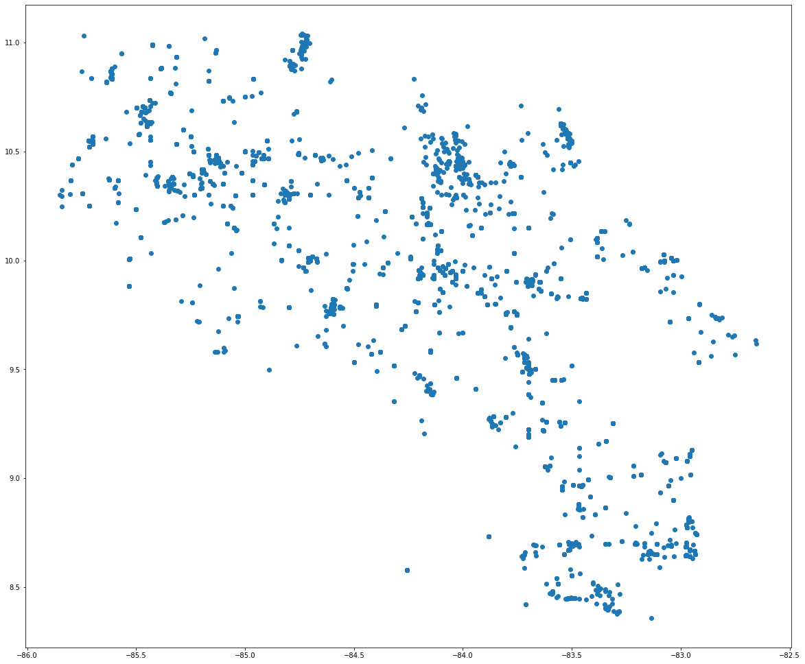
murcielagos = gpd.GeoDataFrame(murcielagos, geometry=gpd.points_from_xy(murcielagos.decimalLongitude, murcielagos.decimalLatitude))
murcielagos.plot(figsize=(20, 20))
<AxesSubplot:>
Capas geoespaciales de Costa Rica
Áreas silvestres protegidas (ASP)
wfs = WebFeatureService(url='http://geos1pne.sirefor.go.cr/wfs', version='1.1.0')

# Parámetros de la solicitud
params = dict(service='WFS',
              version='1.1.0',
              request='GetFeature',
              typeName='PNE:areas_silvestres_protegidas',
              srsName='urn:ogc:def:crs:EPSG::4326',
              outputFormat='json')

# Solicitud
response = requests.Request("GET", "http://geos1pne.sirefor.go.cr/wfs", params=params).prepare().url
response
'http://geos1pne.sirefor.go.cr/wfs?service=WFS&version=1.1.0&request=GetFeature&typeName=PNE%3Aareas_silvestres_protegidas&srsName=urn%3Aogc%3Adef%3Acrs%3AEPSG%3A%3A4326&outputFormat=json'
# Leer datos del URL
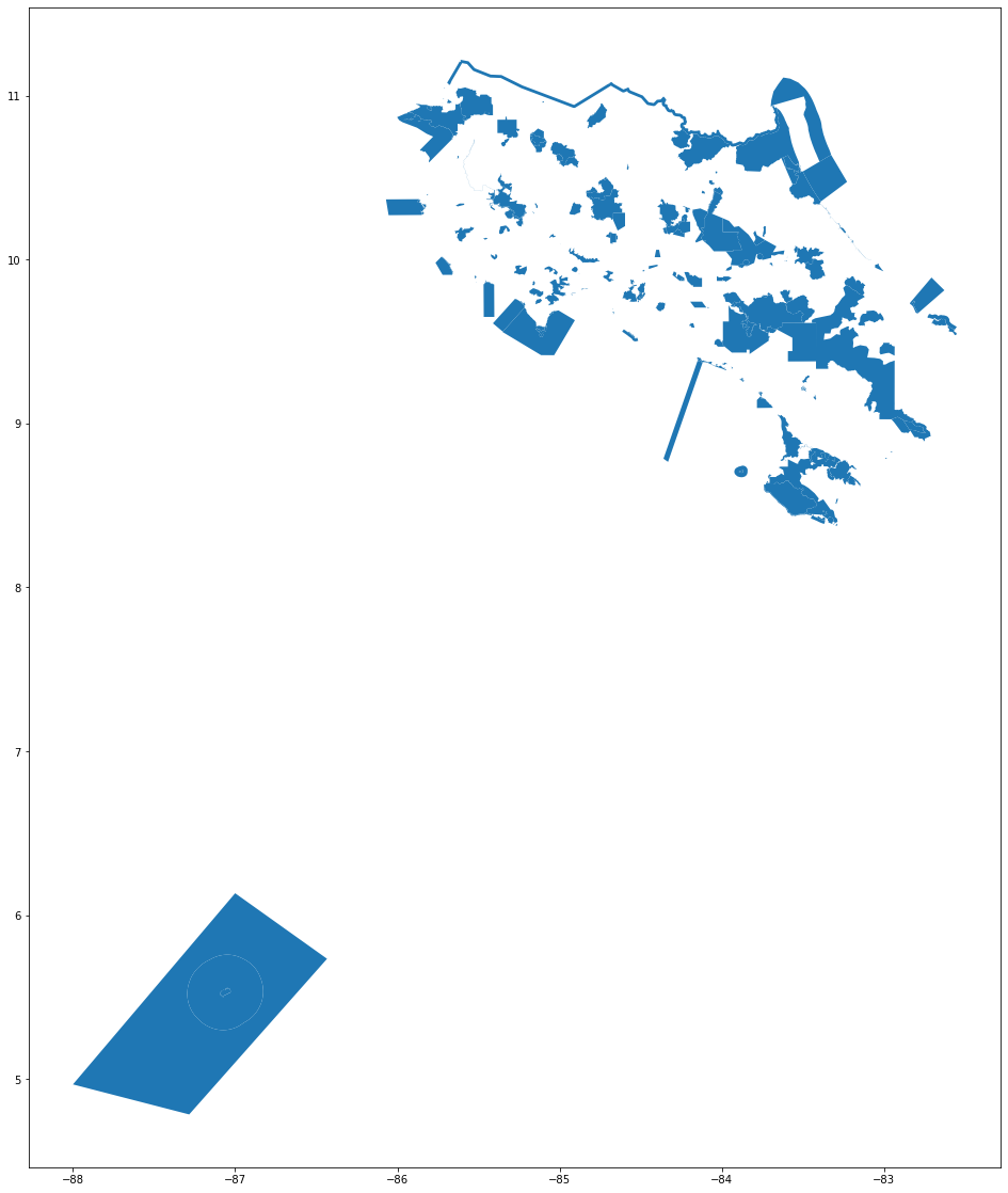
asp = gpd.read_file(response)
asp.plot(figsize=(20, 20))
<AxesSubplot:>
2. Visualización de todas las capas
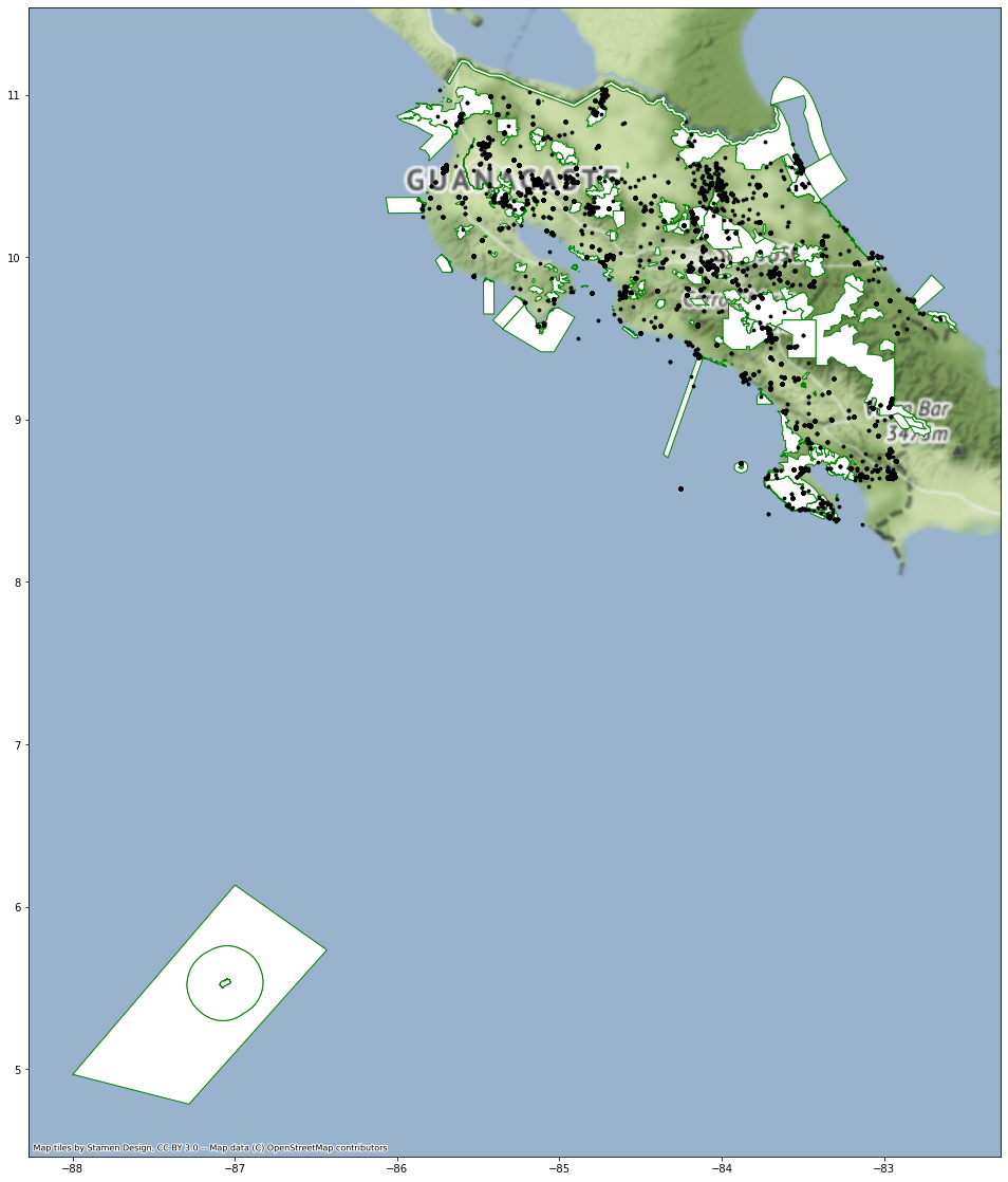
# Mapa con todas las capas

base = asp.plot(color='white', edgecolor='green', figsize=(20, 20))
ax = murcielagos.plot(ax=base, marker='o', color='black', markersize=8)

cx.add_basemap(ax, crs=asp.crs)
3. Conteo de especies en cada polígono
# Join espacial de las capas de ASP y registros de presencia de murciélagos

asp_contains_murcielagos = asp.sjoin(murcielagos, how="inner", op="contains")
/home/mfvargas/miniconda3/envs/pf3311/lib/python3.10/site-packages/IPython/core/interactiveshell.py:3457: FutureWarning: The `op` parameter is deprecated and will be removed in a future release. Please use the `predicate` parameter instead.
  exec(code_obj, self.user_global_ns, self.user_ns)
/home/mfvargas/miniconda3/envs/pf3311/lib/python3.10/site-packages/geopandas/geodataframe.py:1938: UserWarning: CRS mismatch between the CRS of left geometries and the CRS of right geometries.
Use `to_crs()` to reproject one of the input geometries to match the CRS of the other.

Left CRS: EPSG:4326
Right CRS: None

  return geopandas.sjoin(left_df=self, right_df=df, *args, **kwargs)
asp_contains_murcielagos.info()
<class 'geopandas.geodataframe.GeoDataFrame'>
Int64Index: 2221 entries, 13 to 170
Data columns (total 67 columns):
 #   Column                            Non-Null Count  Dtype
---  ------                            --------------  -----
 0   id                                2221 non-null   object
 1   codigo                            2221 non-null   object
 2   nombre_asp                        2221 non-null   object
 3   cat_manejo                        2221 non-null   object
 4   estatus                           2221 non-null   object
 5   siglas_cat                        2221 non-null   object
 6   nombre_ac                         2221 non-null   object
 7   siglas_ac                         2221 non-null   object
 8   descripcio                        2221 non-null   object
 9   a_creacion                        2221 non-null   int64
 10  n_creacion                        2221 non-null   object
 11  normativa                         0 non-null      object
 12  area                              2221 non-null   float64
 13  area_km                           2221 non-null   float64
 14  version                           2221 non-null   object
 15  geometry                          2221 non-null   geometry
 16  index_right                       2221 non-null   int64
 17  gbifID                            2221 non-null   int64
 18  datasetKey                        2221 non-null   object
 19  occurrenceID                      2170 non-null   object
 20  kingdom                           2221 non-null   object
 21  phylum                            2221 non-null   object
 22  class                             2221 non-null   object
 23  order                             2221 non-null   object
 24  family                            2208 non-null   object
 25  genus                             2206 non-null   object
 26  species                           2145 non-null   object
 27  infraspecificEpithet              327 non-null    object
 28  taxonRank                         2221 non-null   object
 29  scientificName                    2221 non-null   object
 30  verbatimScientificName            2221 non-null   object
 31  verbatimScientificNameAuthorship  766 non-null    object
 32  countryCode                       2221 non-null   object
 33  locality                          1921 non-null   object
 34  stateProvince                     1912 non-null   object
 35  occurrenceStatus                  2221 non-null   object
 36  individualCount                   489 non-null    float64
 37  publishingOrgKey                  2221 non-null   object
 38  decimalLatitude                   2221 non-null   float64
 39  decimalLongitude                  2221 non-null   float64
 40  coordinateUncertaintyInMeters     1417 non-null   float64
 41  coordinatePrecision               12 non-null     float64
 42  elevation                         266 non-null    float64
 43  elevationAccuracy                 236 non-null    float64
 44  depth                             6 non-null      float64
 45  depthAccuracy                     6 non-null      float64
 46  eventDate                         2185 non-null   object
 47  day                               2040 non-null   float64
 48  month                             2184 non-null   float64
 49  year                              2185 non-null   float64
 50  taxonKey                          2221 non-null   int64
 51  speciesKey                        2145 non-null   float64
 52  basisOfRecord                     2221 non-null   object
 53  institutionCode                   1913 non-null   object
 54  collectionCode                    2055 non-null   object
 55  catalogNumber                     2089 non-null   object
 56  recordNumber                      953 non-null    object
 57  identifiedBy                      600 non-null    object
 58  dateIdentified                    556 non-null    object
 59  license                           2221 non-null   object
 60  rightsHolder                      659 non-null    object
 61  recordedBy                        1998 non-null   object
 62  typeStatus                        0 non-null      object
 63  establishmentMeans                968 non-null    object
 64  lastInterpreted                   2221 non-null   object
 65  mediaType                         343 non-null    object
 66  issue                             2137 non-null   object
dtypes: float64(15), geometry(1), int64(4), object(47)
memory usage: 1.2+ MB
asp_contains_murcielagos
| id | codigo | nombre_asp | cat_manejo | estatus | siglas_cat | nombre_ac | siglas_ac | descripcio | a_creacion | ... | identifiedBy | dateIdentified | license | rightsHolder | recordedBy | typeStatus | establishmentMeans | lastInterpreted | mediaType | issue | |
|---|---|---|---|---|---|---|---|---|---|---|---|---|---|---|---|---|---|---|---|---|---|
| 13 | areas_silvestres_protegidas.14 | H13 | Humedal lacustrino Rio Canas | Humedal | Estatal | HH | Area de Conservacion Tempisque | ACT | Area terrestre protegida | 1994 | ... | Kristina Yamamoto, Andrea Caiozzi-Cofre (MVZ) | NaN | CC_BY_NC_4_0 | NaN | MALAGA-A., A. | NaN | NaN | 2021-12-02T04:04:03.547Z | NaN | GEODETIC_DATUM_ASSUMED_WGS84;BASIS_OF_RECORD_I... |
| 13 | areas_silvestres_protegidas.14 | H13 | Humedal lacustrino Rio Canas | Humedal | Estatal | HH | Area de Conservacion Tempisque | ACT | Area terrestre protegida | 1994 | ... | Kristina Yamamoto, Andrea Caiozzi-Cofre (MVZ) | NaN | CC_BY_NC_4_0 | NaN | MALAGA-A., A. | NaN | NaN | 2021-12-02T04:04:03.549Z | NaN | GEODETIC_DATUM_ASSUMED_WGS84;BASIS_OF_RECORD_I... |
| 13 | areas_silvestres_protegidas.14 | H13 | Humedal lacustrino Rio Canas | Humedal | Estatal | HH | Area de Conservacion Tempisque | ACT | Area terrestre protegida | 1994 | ... | Kristina Yamamoto, Andrea Caiozzi-Cofre (MVZ) | NaN | CC_BY_NC_4_0 | NaN | MALAGA-A., A. | NaN | NaN | 2021-12-02T04:04:03.548Z | NaN | GEODETIC_DATUM_ASSUMED_WGS84;BASIS_OF_RECORD_I... |
| 13 | areas_silvestres_protegidas.14 | H13 | Humedal lacustrino Rio Canas | Humedal | Estatal | HH | Area de Conservacion Tempisque | ACT | Area terrestre protegida | 1994 | ... | Kristina Yamamoto, Andrea Caiozzi-Cofre (MVZ) | NaN | CC_BY_NC_4_0 | NaN | MALAGA-A., A. | NaN | NaN | 2021-12-02T04:04:03.547Z | NaN | GEODETIC_DATUM_ASSUMED_WGS84;BASIS_OF_RECORD_I... |
| 13 | areas_silvestres_protegidas.14 | H13 | Humedal lacustrino Rio Canas | Humedal | Estatal | HH | Area de Conservacion Tempisque | ACT | Area terrestre protegida | 1994 | ... | Kristina Yamamoto, Andrea Caiozzi-Cofre (MVZ) | NaN | CC_BY_NC_4_0 | NaN | MALAGA-A., A. | NaN | NaN | 2021-12-02T04:04:03.548Z | NaN | GEODETIC_DATUM_ASSUMED_WGS84;BASIS_OF_RECORD_I... |
| ... | ... | ... | ... | ... | ... | ... | ... | ... | ... | ... | ... | ... | ... | ... | ... | ... | ... | ... | ... | ... | ... |
| 170 | areas_silvestres_protegidas.171 | P18 | Internacional La Amistad | Parque Nacional | Estatal | PN | Area de Conservacion La Amistad Pacifico | ACLAP | Area terrestre protegida | 1982 | ... | NaN | NaN | CC_BY_4_0 | Barcode of Life Datasystems | NaN | NaN | NaN | 2021-12-01T17:18:04.335Z | NaN | GEODETIC_DATUM_ASSUMED_WGS84 |
| 170 | areas_silvestres_protegidas.171 | P18 | Internacional La Amistad | Parque Nacional | Estatal | PN | Area de Conservacion La Amistad Pacifico | ACLAP | Area terrestre protegida | 1982 | ... | NaN | NaN | CC_BY_4_0 | Barcode of Life Datasystems | NaN | NaN | NaN | 2021-12-01T17:19:01.362Z | NaN | GEODETIC_DATUM_ASSUMED_WGS84 |
| 170 | areas_silvestres_protegidas.171 | P18 | Internacional La Amistad | Parque Nacional | Estatal | PN | Area de Conservacion La Amistad Pacifico | ACLAP | Area terrestre protegida | 1982 | ... | NaN | NaN | CC_BY_4_0 | Barcode of Life Datasystems | NaN | NaN | NaN | 2021-12-01T17:18:58.795Z | NaN | GEODETIC_DATUM_ASSUMED_WGS84 |
| 170 | areas_silvestres_protegidas.171 | P18 | Internacional La Amistad | Parque Nacional | Estatal | PN | Area de Conservacion La Amistad Pacifico | ACLAP | Area terrestre protegida | 1982 | ... | NaN | NaN | CC_BY_4_0 | Barcode of Life Datasystems | NaN | NaN | NaN | 2021-12-01T17:19:49.491Z | NaN | GEODETIC_DATUM_ASSUMED_WGS84 |
| 170 | areas_silvestres_protegidas.171 | P18 | Internacional La Amistad | Parque Nacional | Estatal | PN | Area de Conservacion La Amistad Pacifico | ACLAP | Area terrestre protegida | 1982 | ... | NaN | NaN | CC_BY_4_0 | NaN | NaN | NaN | NaN | 2021-12-02T15:35:03.172Z | NaN | GEODETIC_DATUM_ASSUMED_WGS84 |
2221 rows × 67 columns
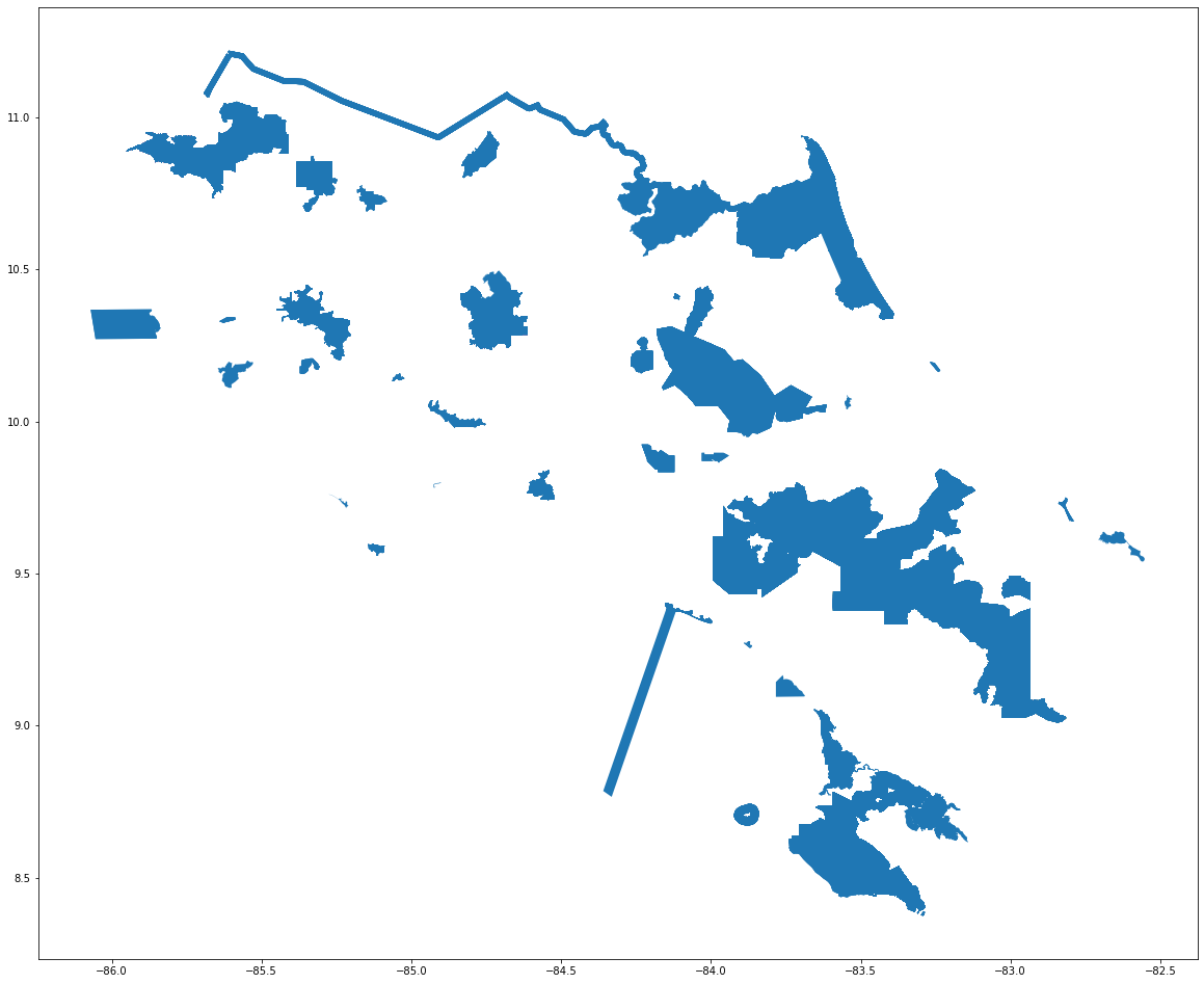
asp_contains_murcielagos.plot(figsize=(20, 20))
<AxesSubplot:>
# Conteo de especies en cada ASP
asp_count_especies = asp_contains_murcielagos.groupby("id").species.nunique()
asp_count_especies = asp_count_especies.reset_index() # para convertir la serie a dataframe

asp_count_especies.rename(columns = {'species': 'especies_murcielagos'}, inplace = True)

asp_count_especies.head(10)
| id | especies_murcielagos | |
|---|---|---|
| 0 | areas_silvestres_protegidas.101 | 2 |
| 1 | areas_silvestres_protegidas.103 | 27 |
| 2 | areas_silvestres_protegidas.107 | 1 |
| 3 | areas_silvestres_protegidas.110 | 2 |
| 4 | areas_silvestres_protegidas.121 | 31 |
| 5 | areas_silvestres_protegidas.124 | 1 |
| 6 | areas_silvestres_protegidas.132 | 1 |
| 7 | areas_silvestres_protegidas.137 | 6 |
| 8 | areas_silvestres_protegidas.139 | 1 |
| 9 | areas_silvestres_protegidas.14 | 1 |
# Join para agregar la columna con el conteo a la capa de ASP
asp_especies = asp.join(asp_count_especies.set_index('id'), on='id', rsuffix='_b')
asp_especies
| id | codigo | nombre_asp | cat_manejo | estatus | siglas_cat | nombre_ac | siglas_ac | descripcio | a_creacion | n_creacion | normativa | area | area_km | version | geometry | especies_murcielagos | |
|---|---|---|---|---|---|---|---|---|---|---|---|---|---|---|---|---|---|
| 0 | areas_silvestres_protegidas.1 | A01 | Montes Submarinos | Area Marina de Manejo | Estatal | AMM | Marina Cocos | ACMC | Area Marina de Manejo | 2011 | DE_36452 | None | 9.592623e+09 | 9.592623e+07 | 2019-11-19-001 | POLYGON ((-87.00000 6.13333, -86.43333 5.73333... | NaN |
| 1 | areas_silvestres_protegidas.2 | A02 | Cabo Blanco | Area Marina de Manejo | Estatal | AMM | Area de Conservacion Tempisque | ACT | Area Marina de Manejo | 1963 | Ley_10 | None | 8.247806e+08 | 8.247806e+06 | 2019-11-19-001 | POLYGON ((-85.14336 9.59649, -85.14332 9.59643... | NaN |
| 2 | areas_silvestres_protegidas.3 | B01 | Alberto Manuel Brenes | Reserva Biologica | Estatal | RB | Area de Conservacion Central | ACC | Area terrestre protegida | 1993 | Ley_7354 | None | 7.800440e+07 | 7.800440e+05 | 2019-11-19-001 | POLYGON ((-84.63388 10.18202, -84.64167 10.177... | NaN |
| 3 | areas_silvestres_protegidas.4 | B03 | Isla Guayabo | Reserva Biologica | Estatal | RB | Area de Conservacion Tempisque | ACT | Isla | 1973 | DE_2858_A | None | 6.268092e+04 | 6.268092e+02 | 2019-11-19-001 | POLYGON ((-84.87710 9.91109, -84.87737 9.91086... | NaN |
| 4 | areas_silvestres_protegidas.5 | B04 | Isla Pajaros | Reserva Biologica | Estatal | RB | Area de Conservacion Pacifico Central | ACOPAC | Isla | 1976 | DE_ 5963_A | None | 3.211583e+04 | 3.211583e+02 | 2019-11-19-001 | POLYGON ((-84.99674 10.09266, -84.99696 10.092... | NaN |
| ... | ... | ... | ... | ... | ... | ... | ... | ... | ... | ... | ... | ... | ... | ... | ... | ... | ... |
| 167 | areas_silvestres_protegidas.168 | Z31 | Quebrada Rosario | Zona Protectora | Estatal | ZP | Area de Conservacion Central | ACC | Area terrestre protegida | 1997 | DE_ 26297_MINAE | None | 4.292695e+05 | 4.292695e+03 | 2019-11-19-001 | POLYGON ((-84.07619 9.70425, -84.07689 9.70374... | NaN |
| 168 | areas_silvestres_protegidas.169 | P10 | Santa Rosa | Parque Nacional | Estatal | PN | Area de Conservacion Guanacaste | ACG | Isla | 1966 | Ley_3694 | None | 3.230258e+06 | 3.230258e+04 | 2019-11-19-001 | MULTIPOLYGON (((-85.87565 10.84304, -85.87571 ... | NaN |
| 169 | areas_silvestres_protegidas.170 | V25 | Bahia Junquillal | Refugio Nacional de Vida Silvestre | Estatal | RVS | Area de Conservacion Guanacaste | ACG | Isla | 1995 | DE_ 23867_MIRENEM | None | 1.836792e+05 | 1.836792e+03 | 2021-08-20-001 | MULTIPOLYGON (((-85.73360 10.95775, -85.73329 ... | NaN |
| 170 | areas_silvestres_protegidas.171 | P18 | Internacional La Amistad | Parque Nacional | Estatal | PN | Area de Conservacion La Amistad Pacifico | ACLAP | Area terrestre protegida | 1982 | DE_13324_A | None | 1.982896e+09 | 1.982896e+07 | 2019-11-19-001 | MULTIPOLYGON (((-82.85282 9.01273, -82.85414 9... | 11.0 |
| 171 | areas_silvestres_protegidas.172 | B09 | Bicentenario de la República - Pájaro Campana | Reserva Biologica | Estatal | RB | Area de Conservacion La Amistad Pacifico | ACLAP | Area terrestre protegida | 2021 | DE_42615_MINAE | None | 5.082743e+07 | 5.082743e+05 | 2021-08-21-001 | POLYGON ((-82.77351 8.94507, -82.81050 8.95856... | NaN |
172 rows × 17 columns
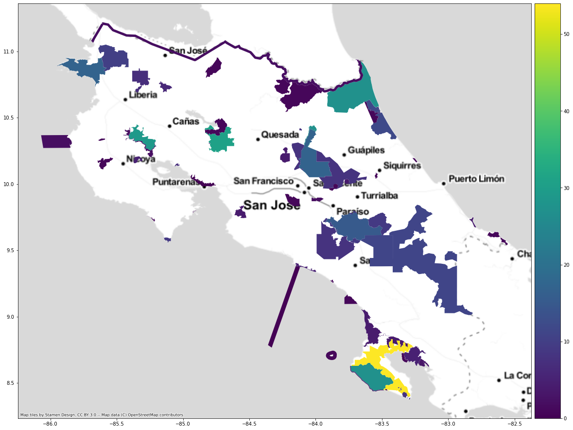
# Mapeo

fig, ax = plt.subplots(1, 1, figsize=(20, 20))

divider = make_axes_locatable(ax)
cax = divider.append_axes("right", size="5%", pad=0.1)

asp_especies.plot(column='especies_murcielagos', ax=ax, legend=True, cax=cax)

cx.add_basemap(ax, crs=asp_especies.crs, source=cx.providers.Stamen.TonerLite)